Design for Manufacturability: Lowering Cost for Mid-Market Equipment Builds
In mid-market equipment builds, cost overruns rarely come from exotic materials or cutting corners. They usually come from designs that are technically sound but difficult to build. Tight tolerances where they are not needed. Too many unique parts. Drawings that leave room for interpretation. Each of these decisions adds friction inside the fabrication shop, and that friction shows up as higher cost, longer lead times, and inconsistent quality.

At Polaris Engineering Group, we approach design for manufacturability as a collaboration between the engineer, the fabricator, and the end user. When those three perspectives are aligned early, equipment becomes easier to build, easier to repeat, and easier to support long term.
Where Unnecessary Cost Often Starts
One of the most common cost drivers we see is overly tight tolerances applied across an entire design instead of where they truly matter. Precision has value, but only when it serves performance, safety, or reliability. Applying tight tolerances everywhere increases machining time, inspection effort, and rework risk without improving how the equipment actually operates.
Excessive variation is another hidden cost. When similar parts are designed slightly differently from one another, fabricators lose the ability to batch work. Every unique plate, bracket, or fastener becomes a custom task instead of a repeatable operation. That is where labor costs quietly climb.
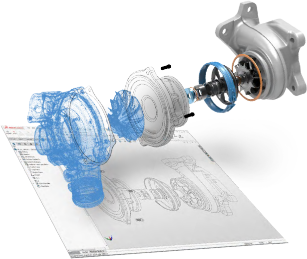
Clear documentation plays a major role here. Even a well designed system becomes expensive if the drawings leave room for interpretation. Good drawings reduce questions, reduce assumptions, and keep production moving.
Designing With the Fabricator in Mind
We work with local fabricators whenever possible. Beyond supporting local industry, this often reduces transportation costs, especially for large skids, trailers, or assembled equipment. Shipping heavy or oversized items across long distances can quickly erase any savings gained from lower fabrication rates elsewhere.
That said, national fabricators still have a place when scale or specialization is required. The key is designing equipment that can be built efficiently in either environment. That means avoiding designs that rely on one specific shop process or tribal knowledge.
A manufacturable design should feel familiar to the shop building it. Common materials, straightforward weld details, and logical assembly sequences go a long way toward keeping costs under control.
Reducing Part Count Without Reducing Performance
One of the most effective ways to lower cost is reducing part count. Fewer parts mean fewer drawings, fewer welds, fewer fasteners, and fewer opportunities for error. We routinely look for ways to combine features or eliminate unnecessary components while maintaining strength and function.
Fastener standardization is another simple win. Using a smaller set of bolt sizes reduces purchasing complexity, speeds up assembly, and minimizes mistakes on the shop floor.
For smaller projects, we often design around bulk material thicknesses. Using consistent plate and tube sizes allows shops to buy material in volume and reduces scrap. This approach does not compromise performance when applied thoughtfully, and it often produces cleaner, more consistent builds.
When Poor Manufacturability Becomes a Bottleneck
A good example comes from a large mobile generator set we reviewed that had been designed by a previous firm. The equipment worked, but the documentation and part standardization were poor. Nearly every trailer had unique parts, which made mass production impossible.
Each unit was effectively built from scratch. Fabricators were forced to custom manufacture components on the fly, which increased labor hours, introduced variability, and slowed delivery.
Our role was to step back and rework the design with manufacturability in mind. We consolidated parts, reduced variation, and created a complete drawing package that allowed the shop to produce components in bulk. Once that happened, production stabilized, costs dropped, and the equipment became scalable.
This was not a redesign driven by performance issues. It was a redesign driven by manufacturing reality.
Blending Shop Experience With End User Needs

Polaris sits between the shop and the client. We listen to fabricators who know what works on the floor, and we listen to operators who know how equipment is actually used in the field. The final design reflects both perspectives.
That balance is what makes equipment cost effective to build, reliable to operate, and practical to maintain. Design for manufacturability is not about simplifying for the sake of simplicity. It is about removing unnecessary complexity so the important parts of the design can do their job.
Conclusion
Lowering cost in mid-market equipment builds does not require cutting corners. It requires designing with intent. When tolerances are applied thoughtfully, parts are standardized, drawings are clear, and fabrication realities are respected, equipment becomes easier to build and easier to scale.
Good manufacturable design saves money before the first piece of steel is cut. It also creates equipment that shops want to build and operators trust in the field. That is where long term value is created.